This week we took a trip to the Eden Project in Cornwall. Our brief was to research different survival strategies whilst we were there.
The mission statement of the Eden Project is:
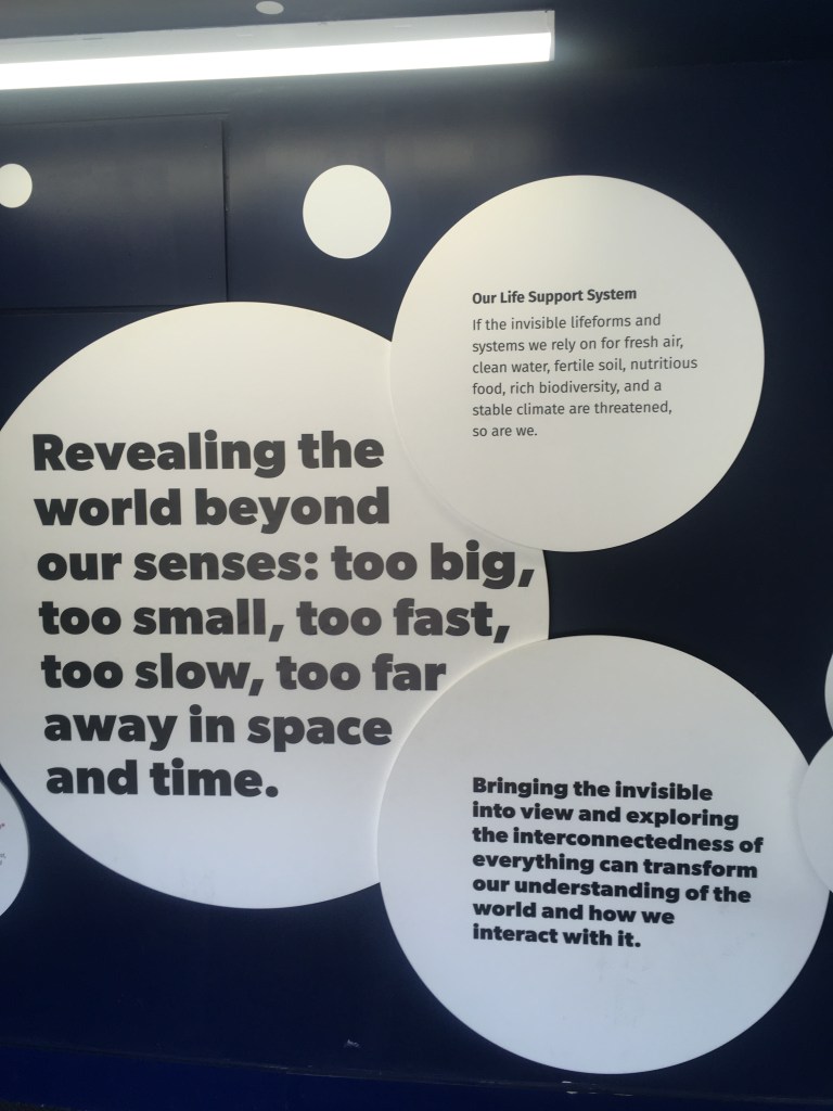
To connect us with each other and the living world, exploring how we can work towards a better future.
In doing so, they hope to combat ‘plant blindness’, which means that we do not realise the myriad ways in which our modern lives are inextricably linked with the natural world around us. From the food that we eat, to the clothes we wear, the medicines we survive by and materials we construct with, we neglect to consider how even most man-made products have in some way been produced using natural resources.
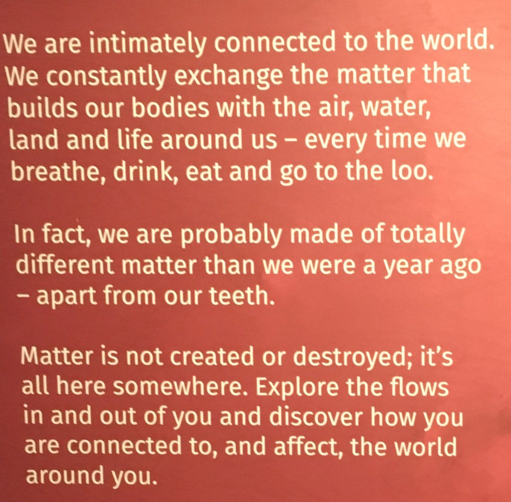
Their primary message is that of interconnectedness between us and the natural world (see below). The very way in which we survive at a total level is because of our place within a whole – we rely on the support of other lifeforms/systems. This interconnection/support system is the ultimate survival strategy which I wanted to explore further.
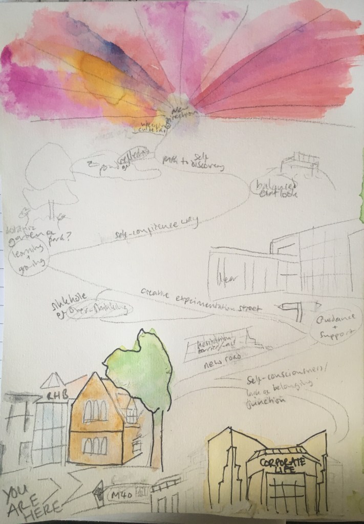
I wanted my journey to show the personal growth I hope for in my FAD – the creativity, discovery, reflection, finding myself/direction, and a positive future. The perils I anticipated needing to overcome were self-criticism, over-thinking, procrastination, self-consciousness, indecision and anxiety.
The sketch/outline for my map – experimenting with materials and features. The journey was refined in my final work to have fewer points of interest
Further reading in the You are here book introduced me to allegorical maps, which also seemed to be relevant to my chosen theme of maps with narrative.
As we navigate on the trip that Dante called ‘our life’s way’, we are all creating private maps… we are laying a new set of lines down on a known but changing world… To orientate is to hop back and forth between landscape and time, geography and emotion, knowledge and behaviour.
Stephen Hall, ‘J. Mercator’ in You Are Here 2004
This extract felt especially relevant to the purposes I had in mind for my map – to help me navigate this new chapter in my life amongst a new landscape – to destinations unknown. How to draw a map to a place not yet known that can only be imagined? I must turn to fiction and allegory, with an element of fantasy.
We need some secure oasis of order, even if only a memory (or a fiction), as a home port for our various explorations, our attempts to make sense of the unknown.
Stephen Hall, as above
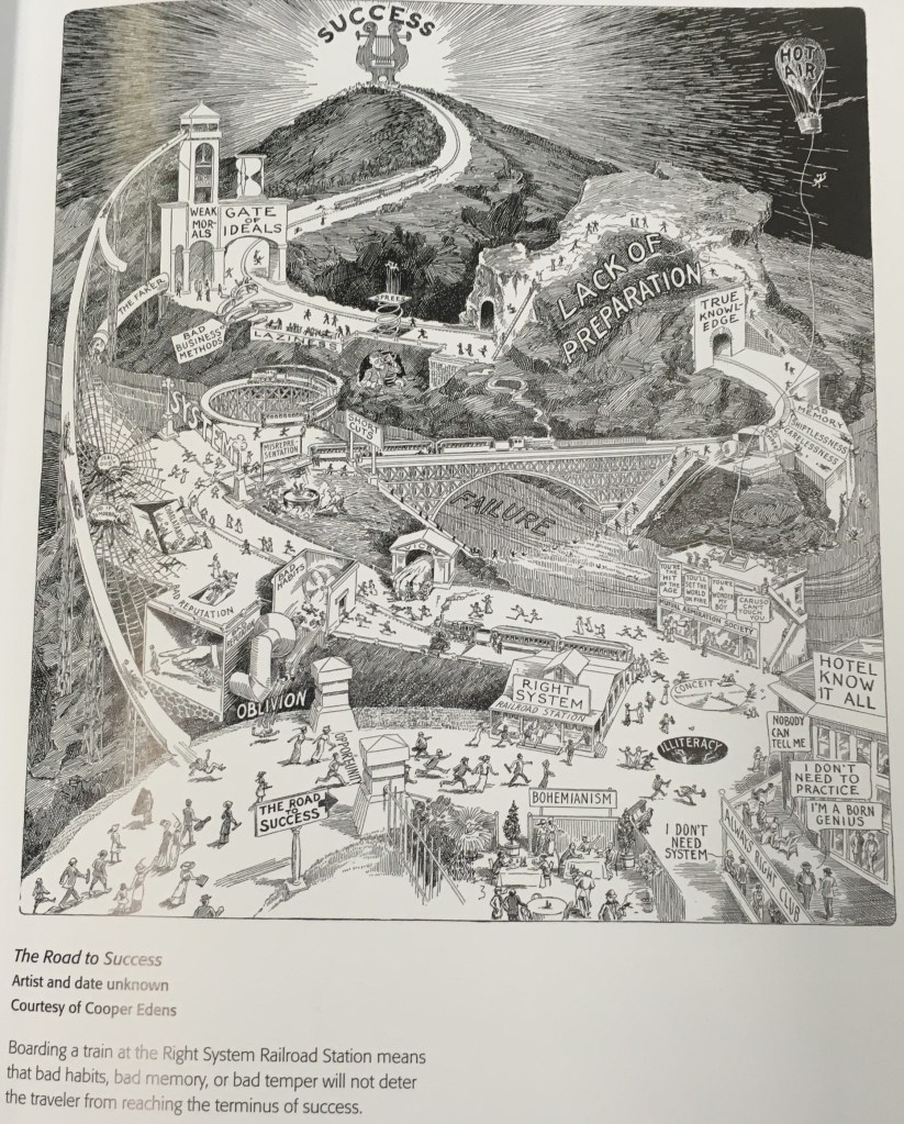
Example in You Are Here
This complicated visual allegory for the Road to Success seemed highly relevant here. Beginning at the bottom left, we follow the individuals setting out in hopes of success and see them facing many obstacles and distractions along the route which snakes up a tall hill, including ‘bad habits’ and ‘shortcuts’ leading straight to the river of failure. The only assured way to get to the top is to get on the ‘right system’ train at the very beginning. This has some troubling overtones of elitism, but the illustrative representation of the narrative here, with pitfalls and a snaking path to indicate time and toil, are of interest. However, I think it is perhaps over-complicated, ominously dark and perhaps not easily grasped by the casual viewer.
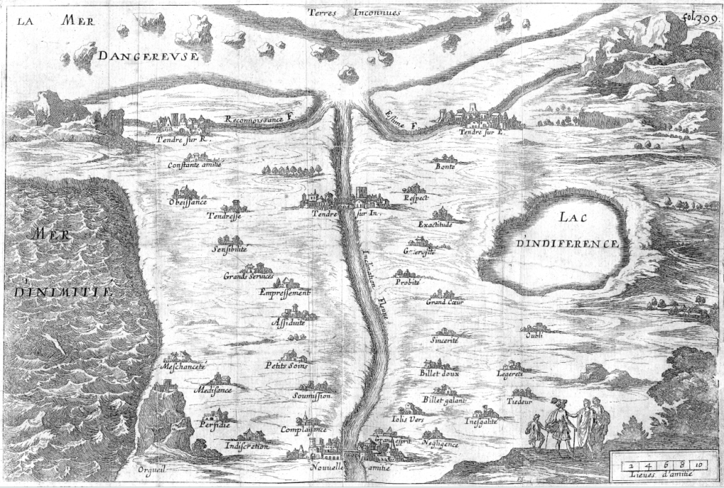
Likely preceding this unknown illustration however was Madame de Scudery, who is attributed as the original creator of allegorical maps with her ‘Carte de tendre’ that features in her 1661 novel Clelie.
Here, Scudery lays out the possible routes and distractions along the course of a woman seeking to journey to ‘Tendre’ from the place of ‘New Friendship’, along the rivers of Recognition, Esteem and Inclination, or along Constant Friendship to the left (past the sea of enmity), and Goodness on the right (past the lake of indifference). Marriage was notably excluded from the map, with Scudery herself believing women should be emancipated from matrimony (as her novel’s heroine is).
As for the previous example, it is noteworthy the map is read from bottom to top, with landmarks used to denote key way markers in progress and/or key obstacles or detours to be avoided in pursuit of the destination. Not unlike a fable or moral tale, it advises the reader and cautions on what to look out for in their own life journey.
I was interested in researching maps that form narratives. So that not only allow you to navigate for a journey, but also acts as a sort of documentation of a particular journey. This initially was to do with the maps at the beginning of fiction books, especially children’s books.
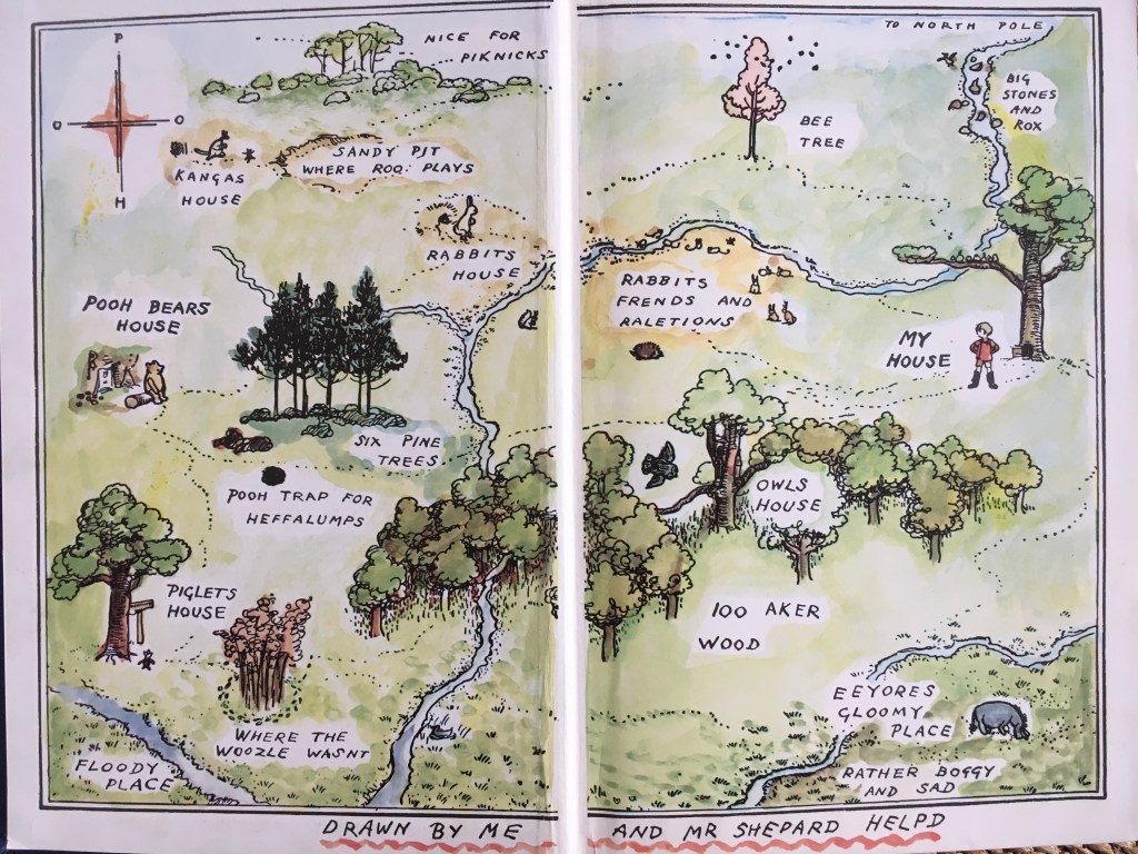
The first and most enduring of these for me, is that of the 100 acre wood in A.A. Milne’s Winnie the Pooh
E.H.Shepard’s map illustration of the 100 acre wood in Winnie-The-Pooh 1926 (coloured 1975)
I especially like the illustrative style here, where the landscape appears flattened, distances shortened, and key elements disproportionately large so that we might recognise them when we later come across them. In a playful mode, spelling is intentionally mistaken, as though a child has written it, e.g. ‘piknicks’, and the naming conventions too are child-like and fantastical, e.g. ‘to north pole’, which is fitting for the intended audience.
Here key places, events, descriptions and characters that feature in the novel are highlighted. This is less to help us navigate the space of the 100 acre wood itself but is providing initial summary of the narrative that will unfold.
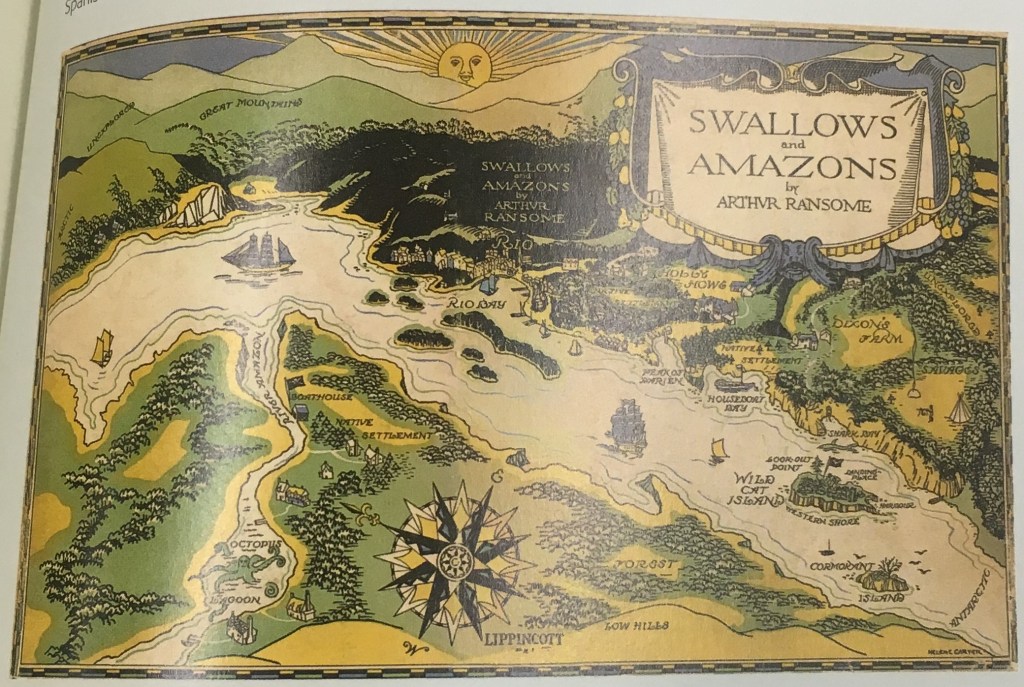
In consulting You Are Here: personal geographies and other maps of the imagination, Harmon, K., 2004 as referenced on our brief, I discovered in Hugh Brogan’s entry that Arthur Ransome (who wrote Swallows and Amazons) had a similar theory: “That pictures in a tale should be useful, not merely ornamental. They should tell the story, as fully and precisely as possible”
Map for Arthur Ransome’s 1930 Swallows and Amazons by Stephen Spurrier – included in You Are Here: Personal geographies and other maps of the imagination, Harmon, K., 2004. New York: Princetown architectural press
Here too Brogan detailed other authors who had included such maps, Tolkien, C.S.Lewis, Ursula le Guin, L. Frank Baum. It is reputed to have begun with Robert Louis Stevenson’s Treasure Island. What all the works of these authors have in common is the fantasy genre, and the ‘letting loose’ of the imagination to truly transport the reader to the unfamiliar. Though many too root this within the familiar.